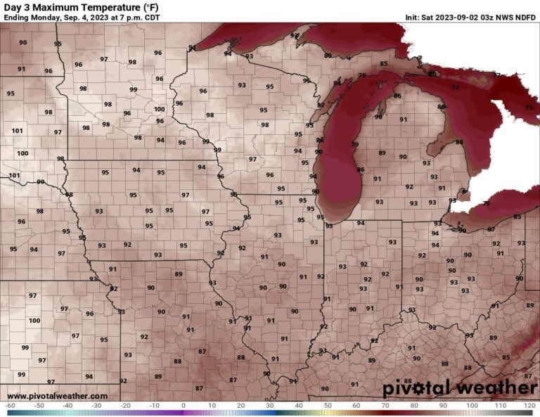
As extreme heat expands northward from its base in the southern United States since June, the number of people likely to be exposed to heat requiring special attention will top 200 million by Labor Day, according to the U.S. Heat Tracker The Washington Post. This heat is most dangerous for infants and children under 4, adults 65 and older, and people who are overweight, sick, or taking certain medications.
Fortunately, the humidity will be lower than it was during the monumental heatwave in the central United States in late August, when heat indices in the Midwest reached near and above 110 degrees. In this next round, heat indices, which describe how hot the air feels when humidity is taken into account, will be close to the actual air temperature. However, those conditions will be quite hot, with many locations reaching daytime highs in the mid-90s to low 100s by Labor Day and only dipping into the 70s for overnight lows.
“Heat of this magnitude is unusual for this time of year and will pose a health risk to those who are not adequately cooled/hydrated,” the National Weather Service said. “Take this heat seriously — especially if you plan to spend time outside over the holiday weekend or participate in early school year outdoor activities.”
Extreme heat dominated the southern tier of the nation throughout the summer, reaching north at times. Many cities from Texas to Florida recorded their hottest August and summer on record. Warm weather is expected to continue along the Gulf Coast next week, especially in Texas, where most of the state is forecast to reach highs near or above 100, or about 6 to 12 degrees above normal.
The heat is increasing this weekend in the Northern Plains and Midwest
Temperatures are likely to soar near or more than 20 degrees above normal across much of the Northern Plains and upper Midwest. Much of Nebraska and South Dakota should experience highs in the upper 90's to low 100's Saturday and Sunday, and mid 90's to near 100 on Labor Day. Meanwhile, much of Iowa and Minnesota soars into the 90s today, with highs near 100 in parts of southwest Minnesota Sunday and Labor Day.
As the heat spreads east, much of Wisconsin and Illinois should reach highs in the low to mid 90s Sunday and Labor Day, with western parts of Wisconsin climbing into the mid to upper 90s. the upper 90s. Much of Michigan, Indiana and Ohio are expected to reach the Labor Day low 90s on Tuesday as well, with highs in the 80s nearing 90 on Wednesday.
Some cities that could tie or break temperature records for specific dates include:
- Sioux Falls, SD, could tie or break the 1956 Saturday day record of 99 points. The city's forecast high for Sunday is near a record 100.
- Minneapolis forecast to reach near 100 degrees on Sunday and Labor Day, possibly breaking records of 97 and 98 on Sunday and Monday. With overnight lows forecast in the mid-70s, the city could also tie or break its daily record for warmest minimum temperature Sunday, Monday and Tuesday.
- Green Bay, Wis., could challenge his daily record three days in a row. The forecast high is near 95 on Sunday and Monday, both of which would be records. Tuesday is forecast to be slightly cooler, but could tie or break the record high of 92 set in 2007. The city could also challenge its daily record for highest minimum temperature on Monday and Tuesday.
- Madison, Wis., could also challenge the daily high records for Sunday, Monday and Tuesday. The forecast high is near 95 on Sunday and Monday, which would break the existing record. Tuesday is forecast to be slightly cooler, but could flirt with the record high of 93.
- Chicago expect a high near 95 on Monday, which could challenge the record high of 95 for the date.
- Detroit expected to reach the low 90s on Monday, which could tie or break the daily high record of 92.
Nebraska and South Dakota are expected to exceed highs in the 80s and 70s Tuesday through Friday, with a cooling trend beginning Tuesday for Iowa and Minnesota. Temperatures in Wisconsin and Illinois drop slightly by Tuesday, though many spots could still reach the low 90s, before dropping into the 80s and 70s on Wednesday. Michigan, Indiana and Ohio will see highs drop into the 80s and 70s by Thursday.
Mid-Atlantic heat arrives Sunday, may last several days
Temperatures are forecast to rise nearly 15 degrees above normal in areas of the Mid-Atlantic. Much of Northern Virginia, Maryland and southern Pennsylvania, including the Washington area, is forecast to warm into the low to mid 90s on Sunday. Those areas could soar into the mid-90s by Labor Day at least through the middle of the week, while the low to mid-90s extend south across much of southern Virginia and North Carolina.
Even Delaware and New Jersey warm briefly into the low to mid 90s on Monday, followed by highs near 90 for much of the week.
Some cities that could tie or break temperature records for specific dates include:
- DC forecast to reach near 95 Monday and Tuesday, likely less than record highs. At Dulles Airport in the western Washington suburbs, both Monday and Wednesday have a chance to tie or break the daily record for highest overnight lows.
- Baltimore It's also expected to reach near 95 on Monday and Tuesday — very close to records on both days.
- Philadelphia forecast to reach near 95 on Monday and Tuesday, near or above existing records.
- Raleigh, NCcould approach its daily record high on Tuesday, with a forecast high of 95.
Models suggest high temperatures in the mid-Atlantic will remain in the 90s through at least Thursday and possibly Friday. Slightly cooler air could arrive by next weekend, although forecast confidence is reduced much earlier.

