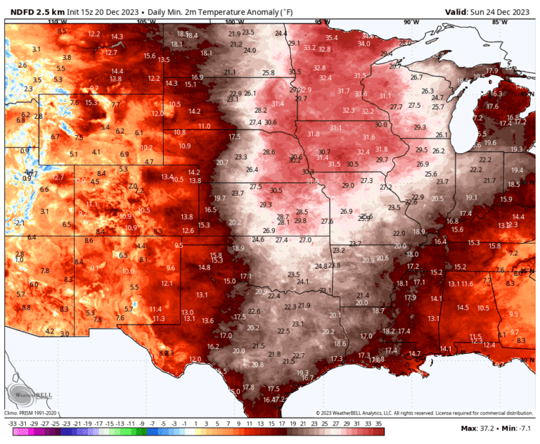
Many locations accustomed to white Christmases in the Upper Midwest and western Great Lakes will have bare ground and temperatures about 30 degrees above normal.
“We are in uncharted weather and climate territory again in Minnesota this December.” wrote Paul Huttner, meteorologist for Minnesota Public Radio. “This will probably be the first time on record that much of northern Minnesota hasn't seen a white Christmas.”
Minneapolis could see record highs on both Christmas Eve and Christmas Day as unseasonable warmth stretches from Texas north of the Canadian border. Some spots could exceed record highs for the calendar day by 5 to 10 degrees.
Several record highs are expected to fall each day as the heat moves north and east. Some have already been placed in the southwestern United States.
Warm air to pour east over the holiday weekend
The warmth is set to spread north and east largely due to a strong Pacific jet stream pulling mild, moisture-laden air into Canada and the northern United States. A strong, slow-moving storm system sweeping across southern California is also helping pull in the mild air.
On Wednesday, much of the western United States saw morning lows 10 or more degrees above average — the start of a record-breaking heat season.
Phoenix was among the Southwest cities that set record warm morning lows. Its low 60 degrees it topped 57 degrees on the same date in 1921 and was 16 degrees above average. Both Los Angeles International Airport and its downtown weather station set warm record lows for the date of 59 and 61 degrees, respectively.
On Thursday, low temperatures at least 20 degrees above average will set records from the Southern Plains to the Midwest. A bunch of additional records are a good bet Friday and Saturday in the same area as warm, moist air funnels northward.
The most extreme heat is expected over the holiday weekend, when morning lows may approach 40 degrees above normal in the Upper Midwest. Afternoon high temperatures should rise 20 to 30 degrees above normal.
Unusually mild weather will spread from Minnesota, Iowa and eastern South Dakota on Saturday into the western half of the Great Lakes on Christmas Day. Many locations that normally see highs in the 20s and 30s this time of year will be in the 40s and 50s.
Cities that could set record highs on Christmas Eve
A white Christmas is virtually out of the question in many places that are used to it because of the temperatures that will be very warm. Below are some locations expected to see record highs on Christmas Eve:
- International Falls, Minn. — The forecast is 42, or about 22 degrees above normal (the record is 42 in 1994).
- Minneapolis — The forecast is 53, or about 27 degrees above normal (the record is 46 in 1957).
- Rockford, Ill. — The forecast is 54, or about 22 degrees above normal (the record is 55 in 2021).
- Sioux Falls, SD — The forecast is 53, or about 24 degrees above normal (the record is 50 in 2021).
Note that International Falls typically has a 93 percent chance of a white Christmas and Minneapolis a 74 percent chance.
A record warm Christmas morning for many
Dozens of locations in the Upper Midwest could record their warmest Christmas mornings on record. Here are some examples:
- Chicago — The forecast is 48, or about 25 degrees above normal (the record is 46 in 1936).
- Duluth, Minn. — Forecast is 37 or about 30 degrees above normal (record is 34 in 1877).
- Eau Claire, Wis. — Forecast is 44 or about 34 degrees above normal (record is 35 in 1936).
While this period of extreme heat is associated with the prevailing jet stream and is enhanced by the El Niño climate, a trend towards less extreme cold in winter has a strong connection to human-caused climate change.
Historically low snow cover area
The lack of snow is both a contributor to and an indicator of the lack of cold in the Lower 48 states. The extent of snow cover on December 21 is the lowest on record dating back to 2003. Snow covered the ground only 14.3 percent of the country.
There is little indication that the snow cover will expand significantly over the next few days.
Snow has not only been depleted in the contiguous United States but also in Canada, where it has also been historically warm.
Environment Canada announced On Tuesday, many locations in Newfoundland and Labrador reached record highs for December as a mild East Coast storm pumped warm, moist air northward.
North American snow cover is also the lowest on record for the time of year and more typical of early April.
The weather pattern may change to a more wintry one in January, although models predict that Canada and the northern tier of the United States will remain somewhat milder than normal.
Jason Samenow contributed to this report.

