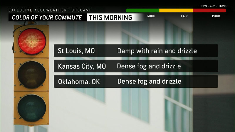
Here are your travel prospects for January 24
Several areas of the country may experience travel delays due to weather conditions on January 24.
Heavy rainfall and the threat of flash flooding remain in the lower Mississippi Valley and much of the Southeast, the National Weather Service said Wednesday night.
The weather service extended flood warnings for some areas as flash flooding was reported in counties in Texas, Louisiana and Mississippi. Additional heavy rainfall and flooding is possible through Friday, with a front expected to drift across the region and possibly stall in the southern Appalachians and lower Mississippi River Valley, raising flooding concerns from Louisiana to southeastern Kentucky and southwestern Virginia .
On Wednesday, the weather service announced:
- More than six inches of rain was reported in 24 hours in Hazlehurst, Mississippi, flooding roads and businesses.
- In Mandeville, Louisiana, between 4.5-6.5 inches of water was reported, causing “significant flooding” on roads.
- Rain rates of 2 inches or more per hour were possible Wednesday night across southeast Louisiana and southern Mississippi, with an additional 4-6 inches of rain possible, threatening flash flooding in New Orleans, Baton Rouge and Hattiesburg.
- In the Houston area, major flooding is expected this week on the Navidad River, the West Fork of the San Jacinto River and the Trinity River, where water could be about two feet above its record high set in September 2017.
Elsewhere, forecasters warned Wednesday that major flooding is possible in Rochester, Minnesota, and the Cleveland, Ohio area as rivers and creeks swell and rise.
In the Midwest and Great Lakes region, freezing rain and snow will spread into the Northeast Wednesday afternoon with light accumulations, the weather service added.
A trend of warmer air across the Midwest, mid-Atlantic and East Coast will cause the snow to melt by Friday with highs in the 40s and 50s.
Florida's peninsula will see warmer weather through Friday, with temperatures reaching 80 degrees.
Meanwhile, coastal rain and mountain snow began Tuesday night in the Pacific Northwest.
Flood warnings across the South East
Torrential rain across the southern US and Texas prompted flood warnings that will remain in place throughout the rest of the week.
The NWS warned of the possibility of flash flooding in southeast Texas through Wednesday afternoon. The area south of San Antonio was also under a severe thunderstorm watch Tuesday night, with warning of meteorologists “golf ball sized hail” in some counties.
Parts of Tennessee were also under a flash flood warning until Thursday afternoon. The NWS warned that some areas of Tennessee, including Memphis, could see up to six inches of rain this weekend.
The majority of Louisiana is bracing for possible excessive rainfall and the possibility of flash flooding on Wednesday. The area, which includes Baton Rouge and New Orleans, was also at a slight risk of severe weather, including “damaging winds and isolated tornadoes,” according to the New Orleans NWS.
Torrential Texas rain traps cars, causes school closures
Wednesday's deluge of rain wreaked havoc on Texas commuters and caused the closure of some schools in the state.
The heavy rains put parts of East and Southeast Texas on alert for flooding. A police vehicle in San Antonio got stuck amid flooding on an access road to Interstate 35. The officer, who made it out safely, was deployed to block traffic from the flooded area but ended up submerged, police said KSAT 12.
All government buildings in Fayette County, between Houston and Austin, were closed Wednesday in response to the rain. Schools in other rural counties around Austin were closed after the area was hit with more than 8 inches of rain in 48 hours.
Mississippi was hit with heavy rain
An area of Mississippi and part of Louisiana could see up to six inches of rain with the possibility of flash flooding Thursday.
Flooding caused by “excessive rainfall” is possible across central Mississippi through Thursday afternoon. The NWS warned.
With a 100% chance of rain on Wednesday, the storms are expected to subject the region to heavy rainfall through Thursday, according to Accuweather.
Freezing rain and dense fog in the Midwest
Thick fog has fallen across the Midwest as some areas brace for freezing rain Wednesday.
The The NWS urged drivers in northern Illinois and northwest Indiana to drive slowly through the cloudy, foggy conditions expected through Thursday.
Commuters in Cleveland and parts of Ohio and Detroit Wednesday morning also faced thick fog with visibility of just 1/4 mile or less.
A period of freezing rain it was expected to pass through southwestern Wisconsin, northwestern Illinois and eastern Iowa, including Cedar Rapids Wednesday morning.
Mississippi weather map
US weather watches and warnings
National Weather Radar
Contributing: Dinah Voyles Pulver, USA TODAY; Associated Press

