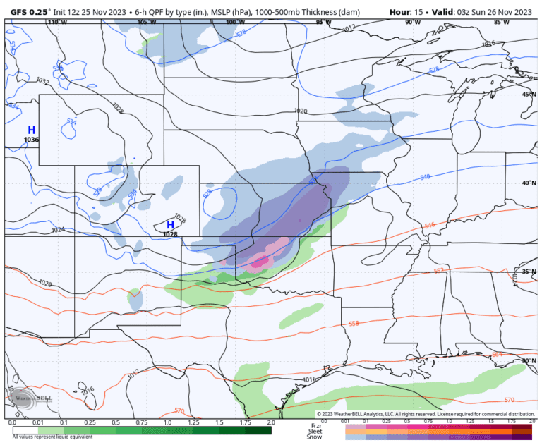
Wichita and Topeka in Kansas. Kansas City, Mo. Chicago; and Milwaukee and Madison, Wisconsin could all experience snow accumulation and some travel disruptions through Sunday night.
The areas affected and forecast for snowfall
The heaviest snow is forecast for central Kansas, where 4 to 8 inches could fall. Wichita and Topeka both are under winter storm warnings where “travel will be difficult” according to the National Weather Service. Much of the snow is expected Saturday and Saturday night before sunny skies return Sunday.
Snow will fall in northern Missouri late Saturday and continue into Sunday morning. Winter weather warnings cover this area including; Kansas City, awaiting the first accumulated snow of the season. The forecast is for 1 to 4 inches.
“The first time for light snow accumulation looks to be between about 5 p.m. this afternoon and 3 a.m. Sunday,” the National Weather Service office serving Kansas City wrote early Saturday.
By early Sunday morning, snow will spread across northern Illinois, Wisconsin and western Michigan. The storm system should weaken somewhat as it moves northeast, so mostly light snow is expected in this area. Generally, snowfall amounts of about 1 to 3 inches are possible with the heaviest amounts in northwestern Illinois.
To Chicagoand Milwaukee and Madison, Wisc., about an inch of snow is forecast, mostly Sunday morning. The National Weather Service office serving Chicago wrote that the snow could create “some minor travel impacts through mid-Sunday.”
In west-central Michigan along Lake Michigan, a narrow band of heavier snow is possible, where about 2 to 4 inches could fall Sunday and Sunday night.
Sunday night into Monday, some snow will sweep inland into the Northeast, while showers develop across eastern New England. Several inches of snow could fall in the high elevations and areas downwind of Lake Erie in western New York and northwestern Pennsylvania.
The heaviest snow of the storm fell in Wyoming on Thursday and Friday, with 22 to 28 inches in Lander, a town of about 7,500 in the middle of the state about midway between Casper and Jackson.
Accumulated snow also fell in Montana, Idaho, Utah, New Mexico, Colorado, South Dakota, Nebraska, western Kansas, and the Texas Panhandle. Here are some selected sets:
- Riverton, Wyo.: 18 inches
- Casper, Wyo.: 11 inches
- Taos, NM: 9 inches
- Cheyenne, Wyo.: 9 inches
- Snowbird and Alta, Utah: 8 inches
- Twin Falls, Idaho.: 8 inches
- Pocatello, Idaho.: 7 inches
- Eldora Ski Area, Colo.: 6 inches
- Park City, Utah: 6 inches
- Boulder, Colo.: 5 inches
- Sheridan, Wyo.: 4 inches
- Dalhart, Texas: 3.5 inches
- Salt Lake City: 3 inches
- Oberlin, Kan.: 1.5 inches
- Denver: 1 inch

