Over the Plains and heartland, an influx of warm, dry air near the front will soak the ground in moisture, sparking concerns about fast-moving wildfires Monday through Tuesday. Red flag warnings for dangerous fire weather extend from the US-Mexico border in Texas to just outside Chicago, affecting nearly 20 million people.
Ahead of the front, unusually warm and moist air blowing north into the Midwest will allow storms to develop on Tuesday, some of which may bring large hail, damaging winds and a few tornadoes. The area from Chicago to Detroit and south to St. Louis is most at risk.
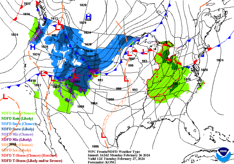
Behind the front, temperatures plummet. That's why winter storm warnings and winter weather advisories cover the high ground of the Mountain West, affecting more than 5 million people. The National Weather Service warns a vast area from Nevada and Montana to Colorado and Wyoming to expect “extensive mountain snow, high winds and hazardous travel.” As temperatures drop farther east by Tuesday, snow will also spread into North Dakota and northern Minnesota, where winter weather advisories are in effect.
Much of the active weather will be near the front, which stretches from Northern California to North Dakota. It is expected to move east and south through the middle of the week before exiting the East Coast.
Ahead of it, record-breaking heat will spread north. Behind it, cold and dry air with a biting wind chill will crash south into a dip in the jet stream.
Colliding air masses will spark strong storms in the Midwest along and ahead of the cold front, while moisture wrapped around the backside of the storm system will lead to snow. Dry air in the storm system's “dry gap” – or wedge of dry air coming in from the southwest – will sweep across the plains. This will create weather conditions favorable for wildfires.
Severe thunderstorm risk Tuesday in the Midwest
Thunderstorms, some severe, will form along and ahead of the cold front Tuesday across the Midwest. They will have a limited supply of fuel, but plenty of wind potential. With the jet stream slicing overhead, a dramatic change in wind speed and/or direction with height, known as shear, will be present.
A few rotating supercells will be possible, with the threat of large hail, damaging winds and tornadoes.
- Level 2 out of 5 A slight risk of severe thunderstorms is projected by the National Weather Service's Storm Prediction Center. It extends from Milwaukee south to Detroit and south to extreme southern Illinois and eastern Missouri. Chicago; Springfield, Ill.; Indianapolis; Toledo? and St. Louis are all in the zone to watch.
- There is an increasing chance that a Level 3 out of 5 an increased risk of severe weather will be introduced into later forecasts, likely from Chicago eastward. That's where a warm front lifting north will provide some extra spin, helping the storms spin.
Windblown snow in the mountainous west and northern lowlands
A disruptive combination of snow and wind means travel problems across the Mountain West through Tuesday, spreading to the northern plains.
Blizzard conditions continue over Oregon and Washington Falls, with snowfall rates of 1 to 2 inches per hour that will shut down travel through the mountain passes. Totals of 2 feet or more are possible in the Cascades above the rain-snow line, with up to 4 feet on the higher mountain peaks.
Moderate to heavy snow will shift into the Great Basin and central Rockies, with winds gusting 50 to 65 mph over higher ground. This will lead to blizzard conditions and almost impossible travel. The Weather Service writes that much of the higher ground has a change of 70 percent or more when it sees accumulations of a foot or more.
Freezing air will crash south behind the front, with temperatures plummeting into the teens and single digits, even in the northern plains. High winds and several inches of snow are forecast for eastern North Dakota and northern Minnesota on Tuesday.
Dangerous fire weather in Pedina
As warm, stormy weather swells northward ahead of the front, dangerous fire weather is already present in West Texas, southeastern New Mexico, and Oklahoma and Texas. There the Storm Prediction Center has described a “critical” fire risk through Monday. A smaller, but still significant, increased fire danger extends into Nebraska and Iowa.
For the Plains, the main drivers of fire weather are two:
- Temperatures are unusually warm, ranging from 20 to 30 degrees above average. That means the 80s and 90s in eastern New Mexico and Texas, with the 60s and 70s for the rest of the plains – very unusual for February. Warmer temperatures evaporate more moisture from the soil, reducing moisture vegetation and drying out the landscape.
- Downwinds or air drawn from high in the Rockies to a lower elevation over the Plains. A band of strong westerly winds associated with the jet mixes at the surface and increases strong westerly winds in the Rocky Mountains and western Plains. As air descends from higher altitudes to lower altitudes, it is compressed, heated and dried. This brings very low humidity levels.
A large area of low relative humidity is forecast to spread across the plains by Monday afternoon, meaning the air will hold very little moisture. Combined with westerly winds gusting 30 to 40 mph, the fires that ignite could spread very quickly.
“Use caution if engaging in activities that could cause a fire,” the Weather Service advises.
Farther east along the Corn Belt, severe to extreme drought conditions will exacerbate fire danger.
Continued wildfire concerns will continue to be an issue Tuesday, especially across the High Plains.
Jason Samenow contributed to this report.

